An inception workshop to form a Community of Practice focused on Unmanned Aerial Vehicles (UAV) and Agricultural Remote Sensing was held at the ILRI Campus in Nairobi on October 7, 2014. The workshop was the platform for launching the discussion on the potential use of UAV in Remote Sensing as an effective tool for improving agricultural statistics.
The workshop – an integral activity of a research project financed by the Bill & Melinda Gates Foundation- was hosted by Roberto Quiroz from CIP headquarters in Lima, Corinne Valdivia, Professor at the University of Missouri, USA and Dieudonné Harahagazwe, Adolfo Posadas and Elijah Cheruiyot all from CIP Nairobi. Thirty-two participants representing national, regional and international institutions based in Kenya, Tanzania, Uganda and Nigeria attended the workshop, including five CGIAR centers (CIP, ICRAF, CIAT, IITA and ILRI) and icipe.
UAV-based remote sensing tools are being developed and constructed by CIP to more effectively monitor and study potato and sweetpotato cropping areas throughout the country. Air-borne remote sensing of plant reflectance make it possible for scientists to observe how crop characteristics such as canopy cover, biomass accumulation, nutrient content, diseases and water use develop and evolve across landscapes over time. . This project is part of a larger effort across the CGIAR, with activities linked to the CGIAR Research Programs on Root, Tubers and Bananas (RTB), Climate Change, Agriculture and Food Security (CCAFS) and on Water, Land and Ecosystems (WLE). It will provide new information about crop statistics, weather, crop performance, resource use, the improved genetic traits sought by crop breeders as well as changes in the landscape.
“Last year CIP received a proof of concept grant from the Bill & Melinda Gates foundation to further the work we have started on remote sensing of cropping areas and crop condition and to assemble a UAV-based low-cost remote sensing platform” said Roberto Quiroz. Roberto goes on to say that the project will “develop methods that can support institutions producing vital agricultural statistics and yield forecast at local and national scales”.
The CIP team is creating opportunities to use remote sensing as a monitoring tool for smallholder farmers. The pilot tests will take place in Tanzania and Uganda using sweetpotato as the pilot crop and aim to provide local institutions with effective and low-cost tools for gathering and processing data on smallholder agriculture.
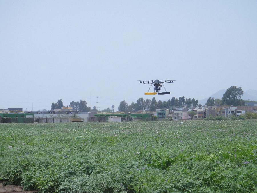
CIP drone project in action
The workshop brought together key stakeholders to discuss innovation as part of the tool-box of users in research, development, statistics and policymaking that ultimately improve agriculture and the quality of life of farmers. This included focus group discussions on the potential for agricultural remote sensing information systems (ARSIS) and the identification of networks and elements of the impact pathways by stakeholder groups.
According to Dr. Quiroz the project aims at developing open access data on UAV-based tools: “All the technology generated by this project must be of free accessibility. Our Center produces international public goods, a policy endorsed by our donor. Thus, all the knowledge, software developed, information on what to buy, where to buy, how to assemble, etc. must be made available for everyone. The idea is that users can download the information and with that assemble the vehicles and sensors and provide the service or information needed by beneficiaries”
The organisers were thrilled with the results of the workshop, especially with the high level of discussions and fantastic connections that were made between stakeholder organisations from across the sub-Saharan Africa region and across a wide variety of fields of practice ranging from core development, applied research, to end users, and enablers.
You can view a collection of photos from the event here.
For more information about the project read this great article: Invasion of the Potato Drones on the CIP Blog or send an e-mail to Dr. Roberto Quiroz at r.quiroz@cgiar.org