MWANZA, Tanzania — Flying a specially equipped drone, a team of CIP researchers from South America and Africa has successfully used remote-sensing technology to obtain data on orange-fleshed sweetpotato fields in East Africa.
The joint study ran for two weeks from late April through early May in Tanzania, where the sweetpotato is increasingly grown by smallholder farmers. Initial image-processing and other analysis of the drone data were completed recently back at CIP-Lima.
“The quality of the data taken was great, and discrimination of land uses and the estimation of the area for each use were achieved with high accuracy,” said Roberto Quiroz, project leader at CIP-Lima.
The goal of the field study was to validate a low-cost, effective method of monitoring sweetpotato crops. The study was part of a larger project, funded by the Bill and Melinda Gates Foundation, to use Unmanned Aerial Vehicles (UAVs) to get more detailed information than satellites can give on crops, including accurate production statistics, onset of diseases and pest infestations, and the effects of climate change.
Such information is key to combatting hunger and helping smallholder farmers make decisions about what crops to grow and when. Researchers hope the remote-sensing system they are developing will be applicable to other crops eventually, too, throughout the developing world.
The Africa project built on work done in Peru by CIP researchers to combine agricultural and aerial technology. It followed an October 2014 workshop in Nairobi, Kenya, aimed at forming a Community of Practice for UAVs and agricultural remote sensing in sub-Saharan Africa.
Although tested in the lab and over experimental fields in Peru, the flights in Tanzania were the first tests under real-world conditions.
“After hundreds of test missions in Peru in both experimental stations and farms, we were very sure the drone and the sensors were ready for field missions in East Africa,” Quiroz said.
Susan Palacios, an image-processing specialist with CIP-Lima who supervised the drone flights in Tanzania, said the team achieved its proof-of-concept mission.
“Our trip was successful, because we tested our knowledge and experiences working in a real field,” Palacios said. “Another important thing is the experience gained. Now we have more information about what it’s like to work in that region and what kind of improvements we need for our acquisition system in software and hardware.”
Among other distinguishing features of the project was its “South-South” collaborative nature — involving experts from Latin America and Africa working together to harness a combination of new technologies to benefit smallholder farmers throughout the tropics.
To the Lake Zone
The setting for the field study was the rural landscape of the Mwanza region of northern Tanzania, some 200 kilometers west of Serengeti National Park. Mwanza is one of three regions that make up the nation’s “Lake Zone” along the southern end of Lake Victoria, the largest lake by area in Africa. Some 12 million farmers work their fields in the Lake Zone to feed their families and earn whatever income they can. These farmers produce more sweetpotato than anywhere else in Tanzania, according to government officials.
After flying from Peru to Kenya, the Lima team members joined other experts from Nairobi and drove to Mwanza city, the capital of Mwanza region and Tanzania’s second largest city.
They carried with them an Oktokopter XL, an-eight propeller UAV similar to the one flown in the earlier research in Peru. But this one had been assembled in Kenya by team member Arnold Bett, a technologist with the University of Nairobi. (The CIP researchers had received permission to fly the drone on farms in Tanzania but were unable to gain permission for flights in Kenya or Uganda.)
Crops in the Lake Zone had just come through an unusual months-long drought during the growing season. Some rain had recently resumed, but fields of such staple crops as maize and rice appeared stunted or dead. Because sweetpotato can grow with intermittent rain, it had fared much better, local agriculturists said.
Over the next week and a half the CIP team ventured out on daily trips into the Lake Zone, meeting with government officials, scientists and farmers to explain the project. After obtaining approval from individual farmers, they gathered data on several farms on the ground and in the air.
Briefing researchers at LZARDI
On their first day in the field, the team met with scientists at the Lake Zone Agricultural Research and Development Institute (LZARDI), in Ukiriguru. Part of Tanzania’s Ministry of Agriculture and Food Security, LZARDI is an agricultural research and promotion agency that focuses on many crops.
Adolfo Posadas, leader of the mission and data processing, explained the goals of the project. He told the LZARDI scientists that as CIP brought the project’s various remote-sensing and aerial technologies together, team members were simultaneously developing a wide range of open-source products — from software for programming flights and processing post-flight images, to instructions for assembling commercially available drones and sensors.
“The principal outcome of this project will be to transfer all of this technology so it is freely available to the next user,” said Posadas, who is currently based at CIP-Nairobi. That would cut costs significantly, even though a commercial UAV would still be needed.
Next, Elijah Cheruiyot, GIS and remote-sensing expert based at CIP-Nairobi, explained the steps the CIP researchers would take in each sweetpotato field. These included measuring the crop’s coverage area and obtaining images using a variety of sensors at different altitudes.
“The drone is just a platform on which we carry our sensors,” Cheruiyot said.
Eventually, the researchers hope, images obtained by drone will be superimposed over larger-scale images from satellites to provide better detail on nationwide crop production than currently possible or affordable.
The LZARDI researchers expressed support and asked several technical questions, then pointed out on a map some possible farm sites where the CIP-led team might gather data.
In a serendipitous surprise, a LZARDI field just a few meters from the conference room proved to be an excellent starting place. That’s because the field contained 14 varieties of orange-fleshed sweetpotato (OFSP) growing side-by-side in different sections. In one place, the CIP researchers could gather a large amount of data about many varieties they had hoped to study.
Within the hour, they were out in that field.
The drone flights
First, they rolled out a long, white measuring tape to mark off rectangular sections of the field. At each of the four corners they drove markers into the ground, taking specific GPS coordinates for each.
Meanwhile, Bett and Luis Silva, a drone pilot and electromechanic based at CIP-Lima, readied the drone, adding propellers, sensors and other finishing touches.
Among the parts they attached was a small black plastic case that secured a multispectral camera to the drone. The case had been custom designed by Silva in Lima, the design data emailed to Bett, and the physical case constructed by a three-dimensional printer in Bett’s lab in Nairobi. This method for producing the case was an example of the kinds of technologies that could be freely available to farmers.
Next, Silva flew the Oktokopter XL smoothly over the field as directed by Palacios. The first flight was with a standard Canon camera and the second was with the multispectral camera, purchased from Tetracam Inc.
The multispectral camera captures and measures light at visible and near-infrared wavelengths. That’s important because each plant variety has a small but measurable difference in the wavelength of light it reflects when in sunlight — a kind of distinctive “signature.” Measuring this spectral signature in field conditions in Africa can help researchers identify from the air whether a crop is sweetpotato, cassava or something else. It can also help them identify what variety of OFSP the crop is.
What’s more, this spectral signature may reveal whether individual sweetpotato plants are thriving and likely to produce many storage roots or whether they are stressed by drought, have a nutritional deficiency or are under attack by a virus or insect. Such changes can be detected in multispectral images before they can be seen in the visible spectrum, scientists say.
Getting spectral signatures with the drone is a key part of the CIP-led remote-sensing project — building what the researchers call a “spectral library” containing signatures for each variety of OFSP.
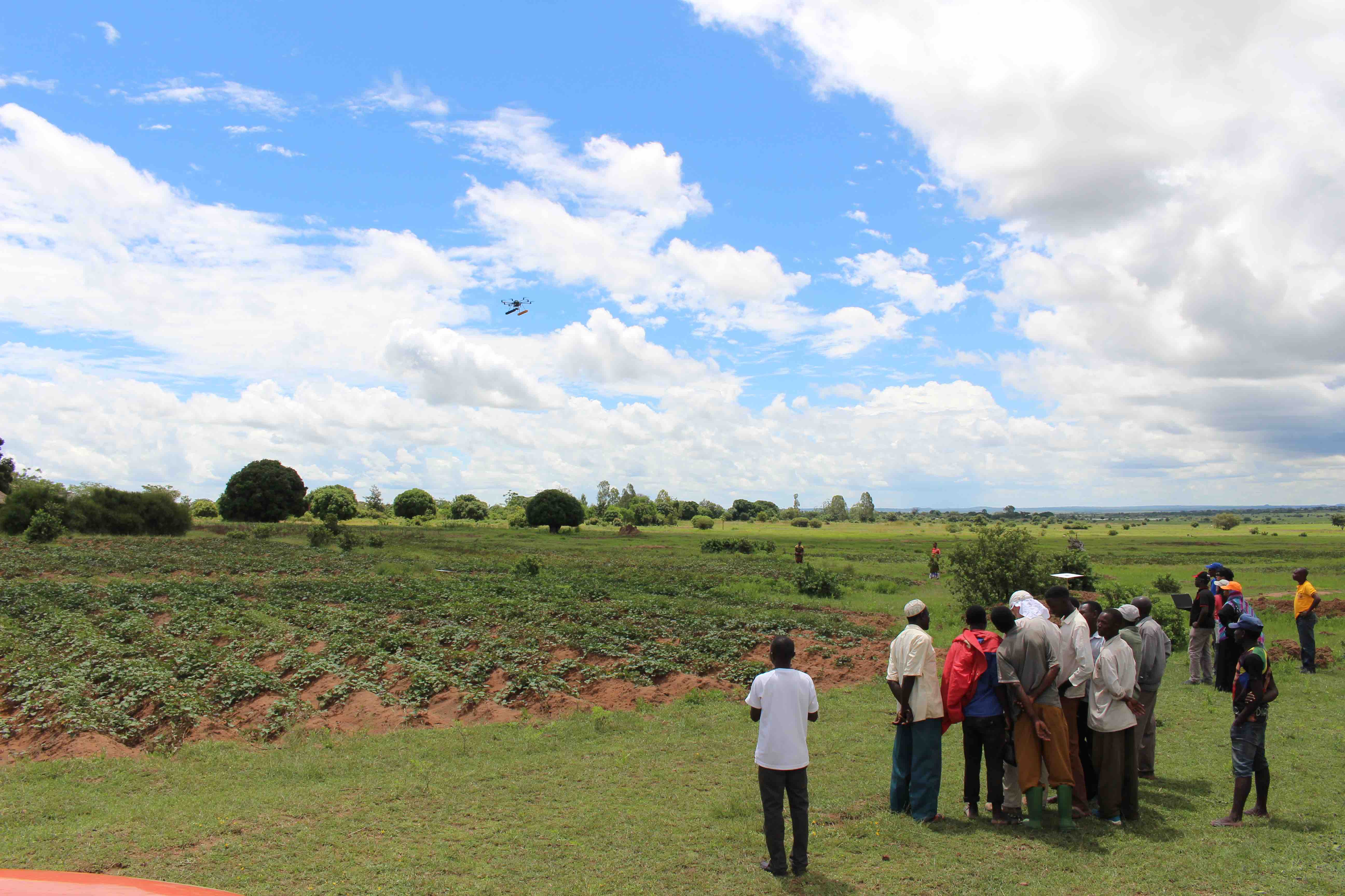
During each of Silva’s flights, the drone hovered above the field taking images at different altitudes, ranging from 5 to 100 meters. This information will help the team determine how close to the plant canopy the drone must fly to get the best images for analysis and to design the methodology for fusing images taken from drone- and satellite-based platforms.
Finally, team members walked the field measuring reflectance of the OFSP varieties at close range.
Thunder rumbled far to the west, and soon the storm rolled over the field and forced the team back into the vehicles, ending that day’s fieldwork.
Reaction from local residents
One of the questions the researchers had on their minds was how local farmers would respond when asked if the CIP team could fly a drone over their crops and obtain images for analysis. The day after their work at the LZARDI field ended, they ventured into more remote regions of the Lake Zone to find out — and were pleasantly surprised.
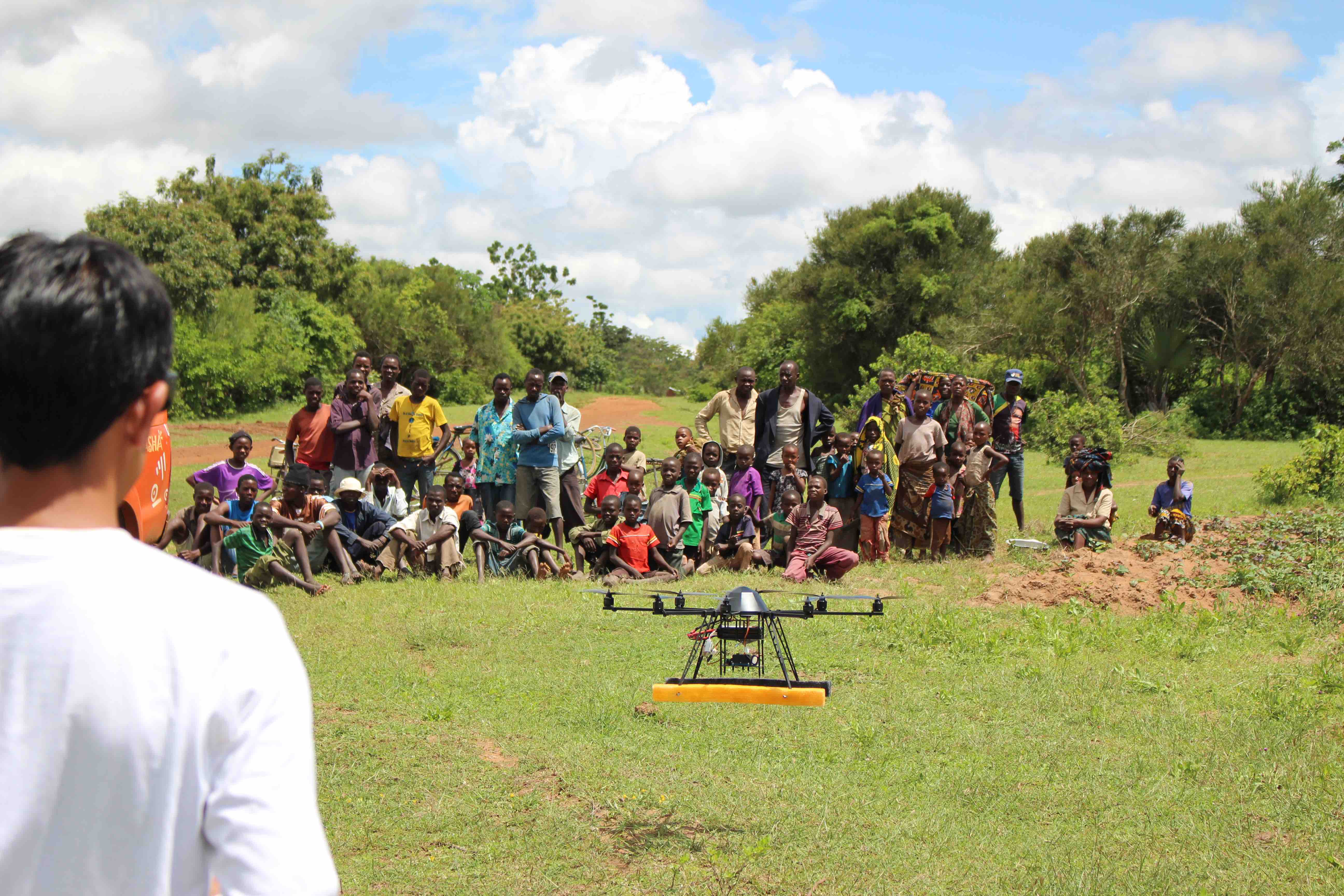
A typical experience came in a field near the village of Ikoma.
After a two-hour drive, much of it on pitted dirt roads, the CIP team, accompanied by LZARDI scientists and local agriculture officials, parked along a vast stretch of sweetpotato fields. Among the vehicles, one stood out: a bright orange Toyota Hilux pickup truck. The truck, which carried the drone, was nicknamed “Sasha” after the acronym for CIP’s Sweetpotato Action for Security and Health in Africa (SASHA) project painted in big white letters on its sides along with the words “for profit and health.”
The view of the site could have made for a scenic postcard. Deep green sweetpotato plots stretched for kilometers in all directions, covering a slight slope dotted with thatched-roof huts and rocks that resembled small elephants in color and shape. The day was hot, and bright puffs of clouds floated across a crystal blue sky.
Within a few minutes, several farmers gathered around, and after a brief discussion they agreed to allow the flights. While some team members took to the field with the measuring tape, others pulled the drone out of Sasha and began the assembly.
Every so often a group of 10 to 30 cattle shuffled up the dirt road, accompanied by two or three men walking swiftly behind them with sticks, whistling. A constant parade of people walked or bicycled up or down the road, some carrying crops or stacks of wood.
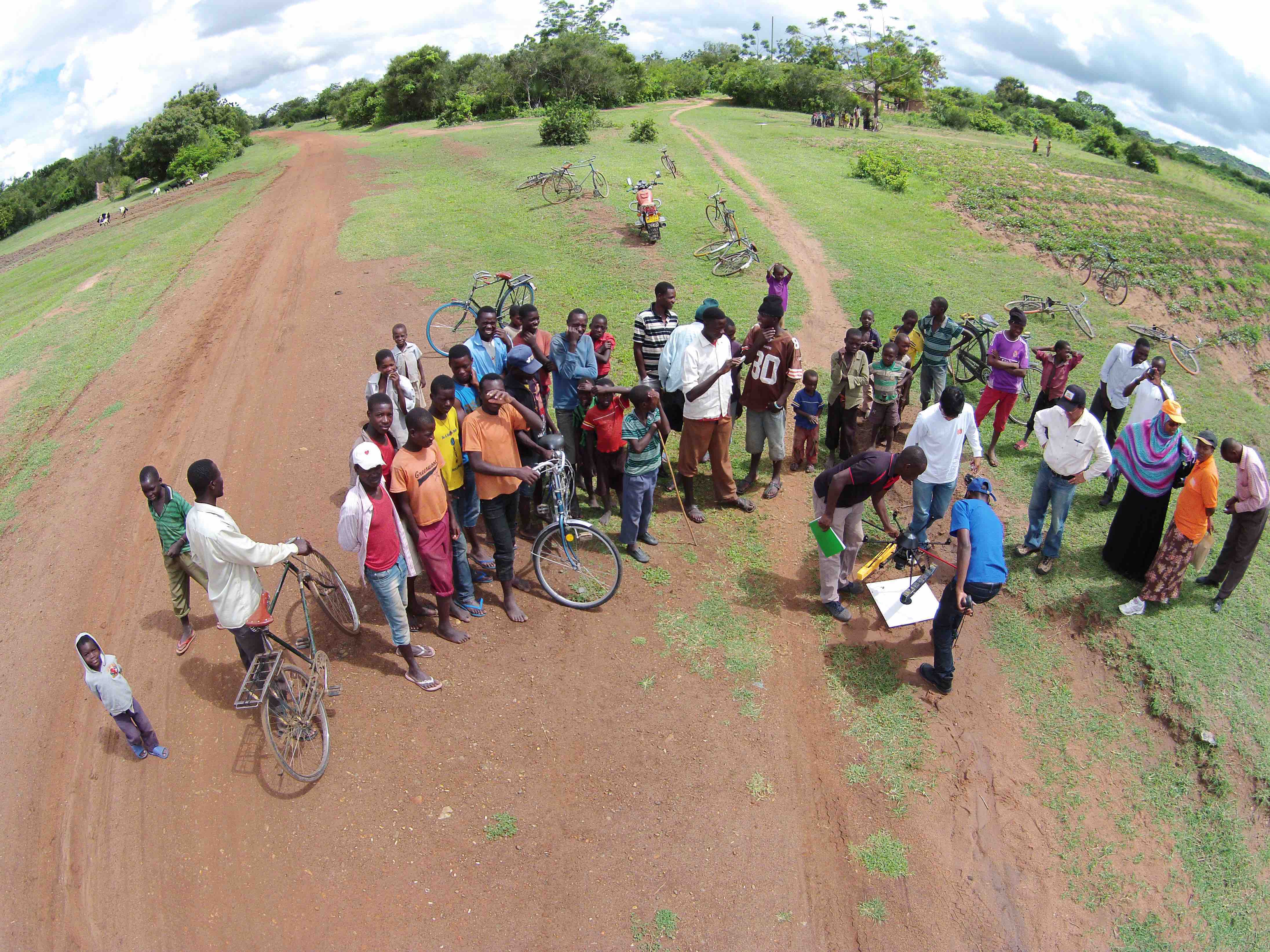
Many stopped to see what was happening. Before long, a crowd of three dozen men, women and children of all ages had gathered around Sasha, and a dozen bicycles rested on their sides not far from the drone as Bett and Silva fitted it with sensors. The villagers watched intently — curious, chatting and often laughing.
Eventually, after a long planning discussion among team members, Silva piloted several flights of the drone above the field to gather data.
Afterward, most of the villagers lingered to watch the team disassemble the drone and pack it away in Sasha. They crowded around a laptop computer to watch aerial videos of the fields taken by a second drone — one piloted by Caleb O’Brien, a journalism graduate student at the University of Missouri-Columbia (MU), USA.
O’Brien was using an MU drone to produce a film documenting the story of the OFSP and the promise that remote-sensing holds for helping smallholder farmers around the world.
“It was important to document the process because these are new technologies that we want to share with other potential developers and users in Africa,” said Corinne Valdivia, Associate Professor of Agricultural and Applied Economics at MU. As part of the UAV and remote-sensing project, Valdivia is studying how these technologies become part of the toolbox for key decision-makers. “They will be instrumental in finding the pathways for reproducing and adapting the technologies for use in their own countries.”
Quiroz, who kept in daily contact with the CIP team from his office in Lima, was pleased with the reaction the team received from the Tanzanians in the field.
“After struggling to get the permit to fly, we were excited about the possibility of seeing the response of the local people to this flying gismo with a weird-looking camera,” he said. “The warm welcome of local professionals and inhabitants to the visitors and their gadgets dissipated the doubts I had.”
Improving crop estimates
In the next several days the CIP team gathered drone-based data from other OFSP fields as well as fields of sweet pepper, cassava, sorghum, cotton, rice and maize. The team returned to Kenya for days of data pre-processing, after which the Lima part of the team flew home.
In an interview before the team left Tanzania, Everina Lukonge, a plant breeder at LZARDI and one of the many scientists who helped the CIP team, said the OFSP was becoming more important in the Lake Zone than ever before, partly because of its ability to produce even under the recent dry weather conditions. And she noted how remote-sensing would be an improvement over the current rough estimates made by crop statisticians.
“Using this drone, they will know exactly the real area for a certain crop which is grown,” Lukonge said. “When the statistics are not known, you cannot estimate even production. If you have this data, it means you can estimate the food. Maybe next season there is hunger. Maybe there is a bumper crop, (so you) look for a market. It can help in planning and budget allocation.”
Now that the CIP researchers have demonstrated the drone-based system’s capability to acquire accurate, high-quality information in real-world conditions, they hope to obtain permission from Kenya and Uganda to fly above other farms so they can expand the study, Quiroz said.
“We just need a permanent permit to move back in and help the local bureau of statistics and other authorities to generate the data they need for improving the quality of agricultural statistics,” he said.
By William Allen
—
- William Allen is an assistant professor of science journalism in the College of Agriculture, Food and Natural Resources at the University of Missouri-Columbia and in the Missouri School of Journalism.
A collection of pictures from the CIP field project is available here.